Keeping a GNSS tripod stable through a survey session
Evaluate the ground, support and cable arrangement so the reference antenna remains where the setup record says it is.
Stability is a session requirement
A tripod setup is complete only when it can maintain the intended antenna position throughout the observation period. A centred and level instrument at the start can move later because of soft ground, loose clamps, cable tension or site activity. For a base receiver, that movement can influence many rover observations. Treat stability as something to monitor over time rather than a photograph taken once during setup.
Consider the duration and purpose of the session. A short inspection and an all day reference operation expose equipment to different conditions. Wind, changing temperature and nearby construction may matter differently at each site. The project procedure should connect the support choice to the intended use without assuming that a tripod is automatically adequate simply because it is a familiar piece of survey equipment.
Continue learning Choosing a suitable GNSS base station site
Inspect the ground and surroundings
Look for firm support at every leg position. Loose fill, wet soil and thin crusts over softer material can allow settlement that is not obvious from the centre of the setup. Inspect drainage and the possibility that the surface will become soft during the session. Avoid choosing a position that depends on an unstable object or a temporary surface whose movement cannot be controlled.
Consider people and machinery as well as soil. A base beside a frequently used path may be bumped, and a cable crossing a working area may be moved. Select a location where the setup can remain undisturbed within the project arrangements. Clear access is useful, but convenience should not place the support where normal site activity repeatedly threatens the reference position or prevents a practical stability inspection.
Continue learning Selecting a site for a continuously operating GNSS reference station
Inspect the tripod and mounting chain
Check legs, hinges, clamps, feet, tribrachs and adapters before use. A loose joint can allow movement even when the legs themselves are well seated. Look for damage from transport and confirm that locking mechanisms hold at the intended extension. Follow the manufacturer instructions for maintenance and tightening; forcing a damaged clamp is not a reliable substitute for restoring a serviceable component.
Inspect the connection to the antenna too. An adapter that can rotate or rock undermines the geometry above an otherwise stable tripod. Identify every component in the mounting chain and check it in the assembled state. Record unusual arrangements or temporary replacements. This is especially important when equipment is shared across crews and a familiar tripod may return with a different tribrach or extension attached.
Continue learning Using forced centering in repeated GNSS setups
Set up in a controlled sequence
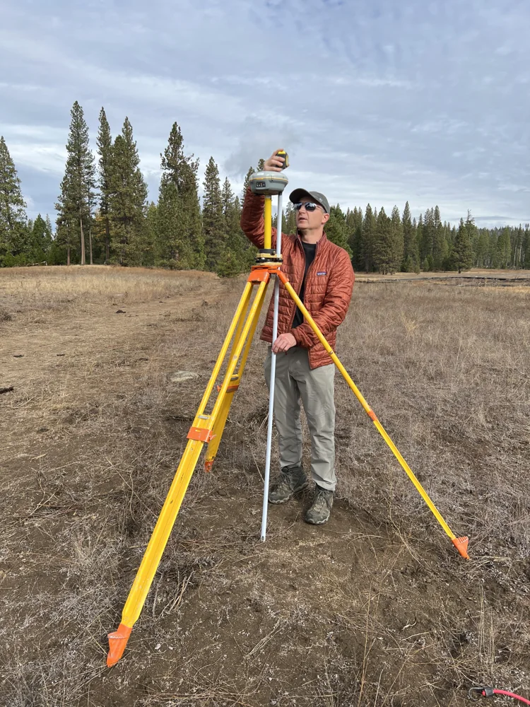
Place the legs securely, centre over the mark and level the assembly using the approved procedure. Tighten the relevant connections and recheck centering and level because adjustments can interact. Measure antenna height after the physical setup is stable. If the tripod is adjusted later, determine whether the height or centering has changed rather than assuming the original measurement still represents the final arrangement.
Arrange cables and power supplies so they do not pull on the antenna or support. Provide enough slack for the intended connection without creating a loose loop that site activity can snag. Keep heavy accessories supported appropriately rather than hanging them from a delicate connector. These details are practical parts of maintaining geometry, not merely tidiness around the instrument after the surveying work has been completed.
Continue learning Choosing and documenting a temporary GNSS base mark
Monitor during observations
Inspect the setup at planned intervals and after events that could disturb it. Note whether the bubble, centering and support appear unchanged. A remote base should have an agreed monitoring arrangement appropriate to the project rather than being forgotten once corrections start. If the setup is photographed during the day, use views that show the support and surroundings as well as the receiver display.
Do not rely on the rover remaining fixed as proof that the base has not moved. The receiver can continue processing observations from a changed physical position. Independent check points and a clear setup history provide different evidence. If a check begins to disagree after a stable period, inspect the base as one possible cause alongside coordinate settings, communications and the rover observation environment.
Continue learning Choosing a suitable GNSS base station site
Respond to suspected movement
Pause affected production and record the time the issue was discovered. Preserve the current setup before making adjustments where practical. Look for a slipped clamp, settled leg, shifted mark contact or pulled cable. Identify the last reliable inspection and coordinate check. Those records help define an interval for review rather than leaving the entire session either automatically accepted or rejected without discrimination.
If the antenna is reset, treat it as a new setup with a new height measurement and verification. Keep the old and new records separate. Recheck independent points and assess production observations from the suspect interval through the project workflow. Do not silently move the tripod back into place and continue under the original setup identifier, because that removes the evidence needed to understand which coordinates may have been influenced.
Continue learning Selecting a site for a continuously operating GNSS reference station
Record what supported the reference
The setup record should identify the mark, antenna, support arrangement, height and inspection times. Include disturbances and corrective actions. A short note such as a leg settling on soft fill is more useful than an unexplained sequence of changed coordinates. Link this record to observation files and rover work periods so later reviewers can connect physical events with the measurements collected during them.
At the end of the campaign, review recurring support problems and improve the site choice or equipment arrangement before the next occupation. A stable tripod is not an isolated hardware property. It is the outcome of suitable ground, serviceable components, careful setup and practical monitoring. Preserving that chain makes the reference position more trustworthy and makes any failure easier to investigate without guessing about what happened in the field.
Continue learning Using forced centering in repeated GNSS setups
A settlement event during a long session
Consider a base operating on ground that softens after rain. If one leg settles, the first diagnostic evidence may be a changed level indication or a failed rover check. Record the discovery time and inspect the support before resetting it. The last documented stable inspection and check help establish the interval that needs review. Avoid assuming that the movement happened at the exact moment it was noticed.
After a reset, create a new setup record with centering, height and coordinate checks. Keep the original observations separate and assess them through the project procedure. If the site repeatedly softens, improve the support location or method rather than planning to correct the tripod whenever it moves. The example shows why stability monitoring and an event log are complementary: monitoring detects a problem, while the log provides the boundaries needed to decide which measurements may have been affected.
Continue learning Choosing and documenting a temporary GNSS base mark
Practical checklist
- Inspect every leg position and the full mounting chain.
- Measure height after final centering and tightening.
- Treat any physical reset as a new documented setup.
Plan your GNSS setup
Compare the EQ10 and EQ20 receiver specifications, then discuss the configuration and support your project needs.
Compare GNSS receivers